immediate future, one of the tools to be incorporated imperatively the task of regional and town planning is to translate the findings under territorial planning a proper software tool that can manage complex databases. That role now represent geographic information systems and, therefore, will be the way to achieve a radical transformation of public land management through the implementation of land administration departments fully computerized.
The geographic information systems (GIS) are a critical mechanism for the analysis of the territories and to allow the assignment of infinite families of determinations, data and characteristics to the ground, allowing for a multiplicity of approaches to understanding the space around us. These mechanisms for the handling of regional data, based on thematic maps are the foundation of the current explosion of geographic information geared for use by common telematic networks like the Internet.
In the case of urban and territorial planning to incorporate these features digital tools have to see, first, with the allocation possible-use regulations or, conversely, the prohibition expressly with the definition of possible actions in each plot, and, secondly, with the completion of the appropriate form of provision on the ground and limiting the intensity of uses in the buildings associated. As a result, GIS can be used very efficiently to perform ongoing management and real-time public authorizations from any changes occurring in the territory. An obvious corollary is the need to translate territorial and urban planning, those documents that establish the explicit definition of future land uses in this type of system.
However, the difficulties of both learning and managing complex and sensitive tools, along with the need for continued commitment to update the information as some administrative apparatus more likely to maintain the inertia of the past are making the implementation of databases and geographic information systems in planning is very slow. For over ten years explained the proper methodological basis for addressing this issue in a special issue of the journal City and Territory (No. 124 2000), however, the current delay in implementation in English local governments evident this serious problem that exists for overcoming the current bureaucratic public land management.
urban management with definition of urban form. Urbanized developments Tegueste PGO. Planning Consultants, Landscape and Architecture, 2009
Explaining in a simplified manner, a geographic information system for land management rests on essentially composed of two groups of components: a spatial segmentation drawn from a particular territory, constituted by independent graphic elements and non-overlapping and alphanumeric database to establish a minimum differential characteristics unique to each piece from the definition of those determinations essential. Including those relating to conditions of use and specific use at each point in that territory. Order to operate the system, a precondition is that both groups are interrelated with the assignment of codes to identify the parts link with groups of data or specific determinations.
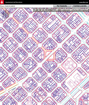
One element that is essential for building the digital system for planning, which supports the database is complete division of the territory in separate areas, and cartographic interpretations that can be assigned different conditions and data. Taking into account the reasons for urban planning, which are often linked to the administrative management of land transformations, the fraction or fragment territorial ideal for this purpose, in principle should be the plot or property valuation.
As such, a condition in this line is the system based on the identification of land ownership, ie the use of cadastral parcel where there is a description appropriate graphic. Moreover, to establish a digital management system of this type, it should be possible to group the various parcels or portions thereof that meet the same conditions that are deemed relevant for administrative purposes. Although the cadastral parcel could be the most appropriate resource to support a land information system is not always possible because it is something that unfortunately is far from existing in most of the planet Its absence in many cases their exact identification errors property or its incompatibility with their own map databases used to describe the soil, which often have substantial differences in design, make the cadastre very doubtful support.
However, a possible second step is referred to the identification of more body parts that may hold at any point within the same real value of the determination that it is associated. It is, for example, the case of apples in more established urban soils, where the building forms and heights are similar and, therefore, the urban use assigned to all parcels comprising necessarily have the same parameter numeric.
Private residential Bonita Springs, Florida. Boston Globe, 30/09/2010
a precondition for the construction of territorial mosaic that would give substance to the information system and land administration is that it has unequivocally established the segmentation of space in two sets of independent and non-overlapping parts: The first group consists of those that make up the public domain, on one hand, in the territorial area (the coast, forests state-owned land, community pastures, roads authorities, etc..) and in urban areas themselves (parks, plazas, streets, etc.). form a second group of pieces that represent the areas of private property (farm land, apples urban, etc.).. To this must be added the components to establish and define the associated information. That is, the different characteristics of each of these parts identified and could refer to the surface, acceptable uses, maximum floor area allocated among many and multiple possible issues.
In digital systems for land administration that are associated with urban planning and rustic, these groups may be grouped or segregated areas in parts of varying size, depending on the applicable determination. For example, a question that can be accepted as part esencial de la ordenación territorial es la determinación que asigna aprovechamiento a las distintas parcelas o aquella otra que establece los usos posibles y prohibidos (residencial, comercial, etc.). Es el caso también de la asignación de un carácter urbano, urbanizable o rústico a grandes piezas de terreno en un territorio concreto.
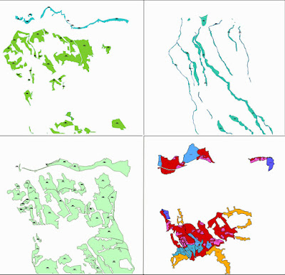
Segmentación del puzzle de la ordenación territorial establecida de acuerdo a su integración en un Sistema de Información Geográfica. PGO de San Juan de la Rambla. Consultores de Planeamiento, Paisaje y Arquitectura, 2010
Pero pueden haber otro tipo determinations of greater complexity and less intelligible, such as those relating to management methods to be applied to achieve a higher level of urbanization of the public space, or those which are required to achieve a free soil for services and amenities without having to purchase or expropriation. This is what some have defined as findings for the management and implementation planning and must necessarily include a significant number of legal conditions that require complex data processing.
Another possibility would be to establish areas that meet minimum uniform criteria for space division. For example, you can split a specific territory traditionally assigned considering its use or that other conditions follow the adoption of specific legislation. We could target a region in the piece of land, wasteland, forest, agricultural and urban with areas used for public road networks that give them access. At each point of the territory would have a particular value system and exclusive to which we may also assign a specific use and conditions to govern the authorization of some uses and activities and the exclusion of others.
Puzzle spatial segmentation of urbanized areas and others that will join the development, planning according to which projects are critical to efficiently direct property transactions, ensuring the greatest improvement and the appropriate safeguards for individuals. Therefore, the quality and accuracy of its graphical definition is crucial to facilitate good governance of space linked to the processes of urbanization and urban transformation.
General Instruction surfaces of a municipality on the island of Tenerife. PGO of San Juan de la Rambla. Planning Consultants, Landscape and Architecture, 2010
From the foregoing, it follows that in practice there are several families of urban spatial determinations that may be associated with the application of management tools. Some have to do with general issues affecting the entire territory and other regulations which specify the conditions applicable to each piece of ground. Among the general range could be set relating to global applications and the classification and categorization of land allocated to large areas of territory that is ordered. For example, the segmentation soils environmental, scenic, agricultural, urban, coastal, etc. The other group that could adjectives as detailed arrangement relate to issues which affect the regulation of the plot in its definition and arrangement of buildings at ground potential, as it affects the establishment of the potential volumes in each case together with the specific regulation of the uses may be authorized in each parcel or lot. Also, it is feasible to establish determinations in the system of territorial management and administration to advance in the definition of the forms of land management so you can make the development and delivery of parcelas dotacionales y las calles urbanizadas a la colectividad de una manera adecuada.
Lo importante para la constitución de un sistema de información territorial útil es que sirva para la consulta rápida de las condiciones que el instrumento urbanístico y territorial establece para cada punto de terreno que se gobierna. Las administraciones públicas, y la sociedad en general, necesitan de formas de ordenación del suelo ágiles y actualizadas, que puedan hacer un uso eficiente de las capacidades informáticas existentes en nuestros días. Unas herramientas de consulta eficaces para poder dirimir lo más conveniente en cada caso con celeridad y transparencia.
Mosaic detailed planning of the historic district of San Juan. PGO of San Juan de la Rambla. Planning Consultants, Landscape and Architecture, 2010
Therefore, planning instruments should focus so they can fulfill this premise from today, to digital delivery systems, since their formulation by providing tools to your query instant verification of the conditions at any stage of administrative procedures related to approval of uses and land use on the ground.
Moreover, the bottom line is that any citizen might be able to access, in simple terms at any time, urban determinations and interpret these conditions laid down in current legislation. Ie make available the data on a specific area for a person who is not qualified specialist is no need for interpreters or intermediaries, to know that you can do there, to calculate with precision about the buildable area assigned and that Ultimately, readily available to urban data and parameters that set the value of a specific property.
The availability of those tools publicly available on the World Wide Web, the Internet is a necessary corollary to this objective and thus would provide the greater public transparency to avoid arbitrary actions that gets used from both the public sphere .--->


